
Suchen
Sie suchten nach:
Type
Image
Filter Type: Image entfernen
Collections
Indiana Historic Maps
Filter Collections: Indiana Historic Maps entfernen
Fach
Subject: IGS Annual Reports
Filter Fach: Subject: IGS Annual Reports entfernen
1 - 5 von 5
Suchergebnisse
-
- Fach:
- Subject: Coal mines and mining, Subject: Caves, Subject: IGS Annual Reports, Subject: Mines and mineral resources, Geographic Subject: Crawford County (Ind.)...
- Schöpfer:
- Collett, John, 1828-1899
- Herausgeber:
- Indiana. Geological Survey
- Datum erstellt:
- 1879
- Identifikator:
- VAC3073-M-01546
- Call Number:
- G4093.C7C5 1878 .C6
- Genre:
- Thematic maps
- Related URL:
- Catalog URL: http://iucat.iu.edu/catalog/18349479
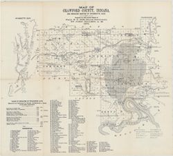
- Abstract:
- Prepared for 10th annual report of Prof. E.T. Cox, State Geologist by John Collett, 1878. Relief shown by hachures. Shows cities and towns, railroads, cavern...
- Alternate Identifier:
- Alternate ID: 390723IP and Title Control Number: a18349479
- Provenance:
- 8th, 9th, and 10th Annual Reports (1876, 1877, 1878) / Indiana. Geological Survey.
- Persistent URL:
- http://purl.dlib.indiana.edu/iudl/images/VAC3073/VAC3073-M-01546
- Geographic Location:
- Coordinates: W0863746 W0861445 N0382324 N0380600, Location Name: Crawford County (Ind.), and Wyandotte Cave (Ind.)
- Caption:
- Imprint: [Indianapolis] : [Geological Survey of Indiana], [1879] and Imprint: [Indianapolis] : [Indianapolis Journal Company, State printers], [1879]
- Physical Description:
- Scale: Approximately 1:125,000 and Print Size: 390723IP
-
- Fach:
- Subject: Indians of North America, Subject: IGS Annual Reports, Subject: Fortification, Prehistoric, Geographic Subject: Hamilton County (Ohio), Subject: Mou...
- Schöpfer:
- Morrison, Samuel (Civil engineer)
- Herausgeber:
- Indiana. Geological Survey
- Datum erstellt:
- 1879
- Identifikator:
- VAC3073-M-01548
- Call Number:
- QE109 .A2
- Genre:
- Pictorial maps
- Related URL:
- Catalog URL: http://iucat.iu.edu/catalog/18387663
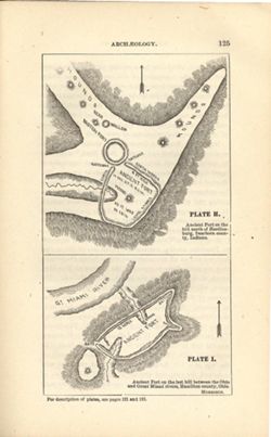
- Abstract:
- At head of first title: Plate H , At head of second title: Plate I. Relief shown by hachures and spot heights. Shows prehistoric forts [Miami Fort and Oberti...
- Alternate Identifier:
- Title Control Number: a18387663 and Alternate ID: 390723IP
- Provenance:
- 8th, 9th, and 10th Annual Reports (1876, 1877, 1878) / Indiana. Geological Survey.
- Persistent URL:
- http://purl.dlib.indiana.edu/iudl/images/VAC3073/VAC3073-M-01548
- Geographic Location:
- Hamilton County (Ohio), Location Name: Dearborn County (Ind.), and Coordinates: W0850758 W0844909 N0391829 N0385607
- Caption:
- Imprint: [Indianapolis] : [Geological Survey of Indiana], [1879] and Imprint: [Indianapolis] : [Indianapolis Journal Company, State printers], [1879]
- Physical Description:
- Print Size: 390723IP and Scale: Scale not given.
-
- Fach:
- Geographic Subject: Indiana, Subject: IGS Annual Reports, Subject: Geology, Stratigraphic, and Subject: Mines and mineral resources
- Schöpfer:
- Cubberley, Ellwood P., 1868-1941
- Herausgeber:
- Indiana. Department of Geology and Natural Resources
- Datum erstellt:
- 1894
- Identifikator:
- VAC3073-M-01570
- Call Number:
- G4091.C57 1893 .C83, no. 15
- Genre:
- Geological cross-sections
- Related URL:
- Catalog URL: https://iucat.iu.edu/catalog/18224924
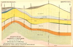
- Abstract:
- Geological cross section showing stratigraphy of mineral resources, including various limestone and shale layers. Relative relief in relation to sea level sh...
- Alternate Identifier:
- Alternate ID: 390726IP and Title Control Number: a18224924
- Provenance:
- 18th Annual Report (1893) / Indiana. Department of Geology and Natural Resources.
- Persistent URL:
- http://purl.dlib.indiana.edu/iudl/images/VAC3073/VAC3073-M-01570
- Geographic Location:
- Location Name: Indiana and Coordinates: W0870500 W0860300 N0414000 N0380000
- Caption:
- Imprint: [Indianapolis] : [Indiana, Dept. of Geology and Natural Resources], [1894] and Imprint: Indpls : lithographed by William B. Burford, [1894]
- Physical Description:
- Print Size: 390726IP and Scale: Approximately 1:1,900,800. 30 miles to the inch. Vertical scale approximately 1:6,000. 500 feet to the inch
-
- Fach:
- Subject: Mines and mineral resources, Subject: Geology, Stratigraphic, Geographic Subject: Indiana, and Subject: IGS Annual Reports
- Schöpfer:
- Cubberley, Ellwood P., 1868-1941
- Herausgeber:
- Indiana. Department of Geology and Natural Resources
- Datum erstellt:
- 1894
- Identifikator:
- VAC3073-M-01571
- Call Number:
- G4091.C57 1893 .C83, no. 16
- Genre:
- Geological cross-sections
- Related URL:
- Catalog URL: https://iucat.iu.edu/catalog/18224924
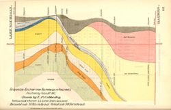
- Abstract:
- Geological cross section showing stratigraphy of mineral resources, including various coal, limestone, and shale layers. Relative relief in relation to sea l...
- Alternate Identifier:
- Alternate ID: 390726IP and Title Control Number: a18224924
- Provenance:
- 18th Annual Report (1893) / Indiana. Department of Geology and Natural Resources.
- Persistent URL:
- http://purl.dlib.indiana.edu/iudl/images/VAC3073/VAC3073-M-01571
- Geographic Location:
- Coordinates: W0873400 W0870100 N0414000 N0383900 and Location Name: Indiana
- Caption:
- Imprint: [Indianapolis] : [Indiana, Dept. of Geology and Natural Resources], [1894] and Imprint: Indpls : lithographed by William B. Burford, [1894]
- Physical Description:
- Print Size: 390726IP and Scale: Approximately 1:1,900,800. 30 miles to the inch. Vertical scale approximately 1:6,000. 500 feet to the inch
-
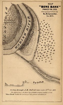
- Fach:
- Subject: Mississippian culture, Geographic Subject: Bone Bank Site (Ind.), Subject: IGS Annual Reports, Geographic Subject: Posey County (Ind.), and Subject:...
- Schöpfer:
- Levette, G. M. (Gilbert M.)
- Herausgeber:
- Indiana. Geological Survey
- Datum erstellt:
- 1874
- Identifikator:
- VAC3073-M-01540
- Call Number:
- G4093.P6E15 1873 .L48
- Genre:
- Pictorial maps and Geological cross-sections
- Related URL:
- Catalog URL: http://iucat.iu.edu/catalog/18308000
- Abstract:
- 1 map and 1 section on 1 sheet. Surveyed and drawn by G.M. Levette Nov. 1873. Shows the "probable western outline of the 'Bone Bank' within the ...
- Alternate Identifier:
- Title Control Number: a18308000 and Alternate ID: 390723IP
- Provenance:
- 5th Annual Report (1873) / Indiana. Geological Survey.
- Persistent URL:
- http://purl.dlib.indiana.edu/iudl/images/VAC3073/VAC3073-M-01540
- Geographic Location:
- Coordinates: W0880126 W0880126 N0374955 N0374955, Location Name: Posey County (Ind.), and Bone Bank Site (Ind.)
- Caption:
- Inds. : Braden & Burford Steam Lith. [1874] and [Indianapolis] : [Geological Survey of Indiana], [1874]
- Physical Description:
- Scale: Not drawn to scale. and Print Size: 390723IP
