
Image
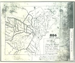
Territorial Limits of Several Tribes, Agreeable, A. Choutea Public Deposited
- Abstract
- Notes of August Chouteau on the Indians of North America, St. Louis, Feb. 21, 1816. Includes "A Map Exhibiting the Territorial limits of Several Nations & Tribes of Indians agreeably to the notes of A. Chouteau reduced, & laid down...by R. Paul, February 1816." National Archives, Records of the Bureau of Indian Affairs. Ancient and Miscellaneous Surveys, vol. 4, A-806.
- Copyright Owner
- Public Domain
- Country
- United States
- Call Number
- GLV137
- Holding Location
- Bloomington - Indiana University Museum of Archaeology and Anthropology
416 North Indiana Avenue
Bloomington, IN 47408
Contact at iumaa@iu.edu, 812-855-6873
- Bloomington - Indiana University Museum of Archaeology and Anthropology
- Persistent URL
- Map Series
- GLOVE - Local and Regional Maps
- Filename
- VAD5944-000020
- Source Metadata Identifier
- Subject
- Indians of North America
- United States--Maps
- American Indians
- Title
- Territorial Limits of Several Tribes, Agreeable, A. Choutea
- Campus
- IU Bloomington
- Creator
- Paul, R.
- Date Created
- 1816
Relationships
Relationships
Items
Show Item Images
| Thumbnail | Title | Date Uploaded | Visibility | Actions |
|---|---|---|---|---|
|
VAD5944-000020.jp2 | 2022-11-02 | Public |
|