
Image
Map of Crawford County, Indiana : and reduced sketch of Wyandotte Cave 公开 Deposited
- Call Number
- G4093.C7C5 1878 .C6
- Genre
- Thematic maps
- Related URL
- Filename
- VAC3073-M-01546
- Subject
- Subject: Coal mines and mining
- Subject: Caves
- Subject: IGS Annual Reports
- Subject: Mines and mineral resources
- Geographic Subject: Crawford County (Ind.)
- Subject: Geology
- Geographic Subject: Wyandotte Cave (Ind.)
- Abstract
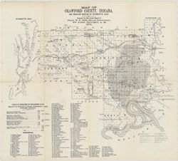
- Prepared for 10th annual report of Prof. E.T. Cox, State Geologist by John Collett, 1878. Relief shown by hachures. Shows cities and towns, railroads, caverns, springs, lime kilns, quarries, mills, and coal. Includes indexed map of Wyandotte Cave with table of distances. "Table of distances in Wyandotte cave. Measured and estimated by Wash. Rothrock, a guide of 28 years' experience." Detached from: Eighth, ninth, and tenth annual reports of the Geological Survey of Indiana, made in the years 1876-77-78. Indianapolis : Indianapolis Journal Company, State printers, 1879.
- Item Identifiers
- Alternate ID: 390723IP
- Title Control Number: a18349479
- Provenance
- 8th, 9th, and 10th Annual Reports (1876, 1877, 1878) / Indiana. Geological Survey.
- Source Metadata Identifier
- Date Created
- 1879
- Physical Description
- Scale: Approximately 1:125,000
- Print Size: 390723IP
- Campus
- IU Bloomington
- Publisher
- Indiana. Geological Survey
- Persistent URL
- Location
- Coordinates: W0863746 W0861445 N0382324 N0380600
- Location Name: Crawford County (Ind.)
- Wyandotte Cave (Ind.)
- Title
- Map of Crawford County, Indiana : and reduced sketch of Wyandotte Cave
- Producer
- Collett, John, 1828-1899
- Caption
- Imprint: [Indianapolis] : [Geological Survey of Indiana], [1879]
- Imprint: [Indianapolis] : [Indianapolis Journal Company, State printers], [1879]
Relationships
关联
- 属于 Collection:
Items
Show Item Images
| 缩略图 | 标题 | 上传日期 | 公开度 | 行动 |
|---|---|---|---|---|
|
VAC3073-M-01546.jp2 | 2023-08-31 | 公开 |
|